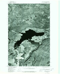
1977 Map of Electric City
USGS Topo · Published 1980About this map
Electric City and Grand Coulee sit at the center of this 1977 orthophotograph, where the massive engineering of the Columbia Basin project meets the desert landscape. Developed from aerial photography by the Geological Survey and Soil Conservation Service, this map provides a direct visual record of the massive water infrastructure and the specialized settlements that grew to support it. The high-contrast imagery clearly defines the complex shoreline and the geometric patterns of human development against the natural formations of the coulee. The prominent landmark of Eagle Rock stands to the southwest, serving as a geographic anchor in a terrain defined by dramatic vertical relief and large-scale water management. This specific format of map, using photographic imagery rather than traditional line-work contours, captures the exact texture of the land and the density of the built environment during the late 1970s.
Find a feature on this map
3 named features on this map. Tap any name to fly to it.
Don’t see what you’re looking for? This feature index may not catch every label — zoom into the map to look around manually.
Map Details
Editions of this 1977 Electric City Map
This is the sole edition of this map. No revisions or reprints were ever made.
Other maps of this area

1948 · Grand Coulee Dam
USGS Topo · 1:62,500

1950 · Grand Coulee Dam
USGS Topo · 1:62,500

1950 · Nespelem
USGS Topo · 1:62,500

1950 · Alameda Flat
USGS Topo · 1:62,500

1952 · Alameda Flat
USGS Topo · 1:62,500

1953 · Ritzville
USGS Topo · 1:250,000

1954 · Okanogan
USGS Topo · 1:250,000

1958 · Okanogan
USGS Topo · 1:250,000

1959 · Ritzville
USGS Topo · 1:250,000

1965 · Ritzville
USGS Topo · 1:250,000