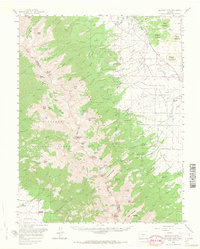
1959 Map of Electric Peak
USGS Topo · Published 1965About this map
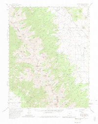
Electric Peak and the high ridges of the San Isabel National Forest dominate this mid-century survey of the Sangre de Cristo Mountains. The terrain is defined by steep glacial cirques and high-altitude water bodies such as Lakes of the Clouds, Hermit Lake, and Banjo Lake. While the western slopes in Saguache County remain largely wilderness, the eastern foothills in Custer County show the marks of early settlement and resource extraction. Evidence of the region's industrial past appears at the Cloverdale Mine and an Old Railroad Grade that skirts the southern boundary. Local genealogy is anchored by the Ula Cem and named family properties including the King Homestead and Hutchinson Homestead. Small communities and recreational sites like Luton, Tanglewood Acres, and Abbots Lodge indicate the transition from a mining and ranching economy toward seasonal mountain tourism.
Find a feature on this map
134 named features on this map. Tap any name to fly to it.
Don’t see what you’re looking for? This feature index may not catch every label — zoom into the map to look around manually.
Map Details
Editions of this 1959 Electric Peak Map
6 editions found

Other maps of this area

1889 · Canon City
USGS Topo · 1:125,000

1889 · Huerfano Park
USGS Topo · 1:125,000

1892 · Huerfano Park
USGS Topo · 1:125,000

1892 · Canon City
USGS Topo · 1:125,000

1950 · Valley View Hot Springs
USGS Topo · 1:24,000

1954 · Trinidad
USGS Topo · 1:250,000

1954 · Pueblo
USGS Topo · 1:250,000

1955 · Westcliffe
USGS Topo · 1:24,000

1955 · Trinidad
USGS Topo · 1:250,000

1957 · Pueblo
USGS Topo · 1:250,000