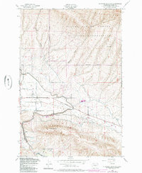
1953 Map of Elephant Mountain
USGS Topo · Published 1985About this map
Moxee Valley irrigation and military infrastructure dominate this mid-century landscape east of Yakima. The northern half of the sheet is occupied by the high, ridged terrain of the Yakima Firing Center Military Reservation, where Yakima Ridge gives way to deep erosions like Washout Gulch. In the lower agricultural basin, the complex plumbing of the high desert is visible through the winding course of the Roza Canal, supported by numerous Siphons and a dedicated Pumping Sta.
Find a feature on this map
26 named features on this map. Tap any name to fly to it.
Don’t see what you’re looking for? This feature index may not catch every label — zoom into the map to look around manually.
Map Details
Editions of this 1953 Elephant Mountain Map
3 editions found
Other maps of this area

1910 · Zillah
USGS Topo · 1:125,000

1936 · Yakima East
USGS Topo · 1:48,000

1936 · Hog Ranch Buttes
USGS Topo · 1:48,000

1941 · Black Rock Spring
USGS Topo · 1:62,500

1941 · Yakima East
USGS Topo · 1:62,500

1950 · Yakima
USGS Topo · 1:250,000
1953 · Black Rock Spring NW
USGS Topo · 1:24,000

1953 · Pomona
USGS Topo · 1:24,000
1953 · Black Rock Spring SW
USGS Topo · 1:24,000

1953 · Elephant Mountain
USGS Topo · 1:24,000