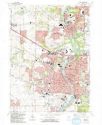
1992 Map of Elgin
USGS Topo · Published 1992About this map
The Fox River valley serves as the central corridor for this 1992 revision, documenting a period of significant suburban expansion between Elgin and Carpentersville. The landscape is a mix of long-established civic institutions and new residential subdivisions, highlighted by the sprawling grounds of the Elgin State Hospital and its associated State Hospital Cem. The industrial and transportation history of the Fox River towns is evident in the presence of the Chicago and North Western rail line and the historic Dundee Sta in East Dundee. Neighborhood character is defined by a high density of parochial and public schools, such as Elgin Academy and St Edwards High Sch, alongside numerous parks and forest preserves like Wing Park and Lords Park. The map also captures the distinct village of Sleepy Hollow and the transition from dense urban street grids to the more open spaces of Binnie County Forest Preserve and several Gravel Pits.
Find a feature on this map
90 named features on this map. Tap any name to fly to it.
Don’t see what you’re looking for? This feature index may not catch every label — zoom into the map to look around manually.
Map Details
Editions of this 1992 Elgin Map
This is the sole edition of this map. No revisions or reprints were ever made.
Other maps of this area

1908 · Wheaton
USGS Topo · 1:62,500

1923 · Barrington
USGS Topo · 1:62,500

1925 · Elgin
USGS Topo · 1:62,500

1932 · Geneva
USGS Topo · 1:62,500

1935 · Barrington
USGS Topo · 1:62,500

1940 · Elgin
USGS Topo · 1:62,500

1948 · Wheaton
USGS Topo · 1:62,500

1948 · Geneva
USGS Topo · 1:62,500

1949 · Geneva
USGS Topo · 1:24,000

1953 · West Chicago
USGS Topo · 1:24,000