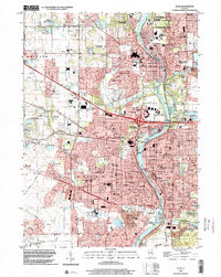
1998 Map of Elgin
USGS Topo · Published 2002About this map
The Fox River corridor anchors this detailed late-twentieth-century study of Elgin and its surrounding communities. At this time, the suburban landscape is a dense network of residential growth, industrial sites, and educational institutions such as Judson College and Elgin Community College. The river's influence is evident in the cluster of settlements including West Dundee, East Dundee, and South Elgin, while the Northwest Tollway and the Chicago and North Western railroad indicate the region's importance as a transportation hub. A significant number of civic and religious landmarks are documented, from the sprawling grounds of the Elgin State Hospital to numerous parish schools and churches like St Marys School. The map also highlights a robust system of protected lands, including the Burnidge County Forest Preserve and Fox River Shores County Forest Preserve, balancing the intense urban development with ecological buffer zones along Tyler Creek and Jelkes Creek.
Find a feature on this map
97 named features on this map. Tap any name to fly to it.
Don’t see what you’re looking for? This feature index may not catch every label — zoom into the map to look around manually.
Map Details
Editions of this 1998 Elgin Map
This is the sole edition of this map. No revisions or reprints were ever made.
Other maps of this area

1908 · Wheaton
USGS Topo · 1:62,500

1923 · Barrington
USGS Topo · 1:62,500

1925 · Elgin
USGS Topo · 1:62,500

1932 · Geneva
USGS Topo · 1:62,500

1935 · Barrington
USGS Topo · 1:62,500

1940 · Elgin
USGS Topo · 1:62,500

1948 · Wheaton
USGS Topo · 1:62,500

1948 · Geneva
USGS Topo · 1:62,500

1949 · Geneva
USGS Topo · 1:24,000

1953 · West Chicago
USGS Topo · 1:24,000