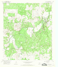
1967 Map of Eliasville
USGS Topo · Published 1970About this map
The Clear Fork Brazos River winds dramatically through the boundary of Young Co Stephens Co, defining a landscape where industrial activity meets rural Texas settlements. This late-1960s environment is shaped by the presence of numerous oil wells and infrastructure, including a local Refinery and a significant Pipeline network. The community of Eliasville sits at a prominent bend in the river, adjacent to the Chicago Rock Island and Pacific railroad line that cuts through the southern portion of the quadrangle.
Find a feature on this map
19 named features on this map. Tap any name to fly to it.
Don’t see what you’re looking for? This feature index may not catch every label — zoom into the map to look around manually.
Map Details
Editions of this 1967 Eliasville Map
2 editions found
Other maps of this area

1890 · Breckenridge
USGS Topo · 1:125,000

1925 · Graham 4-c
USGS Topo · 1:48,000

1925 · Breckenridge 1-b
USGS Topo · 1:48,000

1927 · Graham
USGS Topo · 1:62,500

1931 · Ivan
USGS Topo · 1:62,500

1954 · Abilene
USGS Topo · 1:250,000

1954 · Wichita Falls
USGS Topo · 1:250,000

1958 · Wichita Falls
USGS Topo · 1:250,000

1958 · Abilene
USGS Topo · 1:250,000

1958 · Breckenridge
USGS Topo · 1:24,000