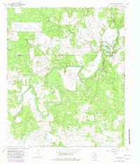
1967 Map of Eliasville
USGS Topo · Published 1982About this map
The Clear Fork Brazos River snakes through the borderlands of Young and Stephens Counties, defining a landscape shaped by both hydrology and the petroleum industry. Near the settlement of Eliasville, the river’s course is controlled by structures like Humble Dam and Texas Dam, reflecting the mid-century infrastructure required for local resource management. The map reveals an intensive industrial footprint characterized by numerous Oil Wells and a Refinery, alongside vestiges of earlier transit such as an Old Railroad Grade. This industrial presence is balanced by quiet local landmarks like Hill Cem, Donnel Cem, and Yellow Fork Cem, providing essential points of reference for genealogists tracking family plots in this corner of North Texas. Tributaries such as Peach Creek and Lodge Creek carve through the terrain, further illustrating the complex drainage patterns of the Brazos basin.
Find a feature on this map
22 named features on this map. Tap any name to fly to it.
Don’t see what you’re looking for? This feature index may not catch every label — zoom into the map to look around manually.
Map Details
Editions of this 1967 Eliasville Map
2 editions found
Other maps of this area

1890 · Breckenridge
USGS Topo · 1:125,000

1925 · Graham 4-c
USGS Topo · 1:48,000

1925 · Breckenridge 1-b
USGS Topo · 1:48,000

1927 · Graham
USGS Topo · 1:62,500

1931 · Ivan
USGS Topo · 1:62,500

1954 · Abilene
USGS Topo · 1:250,000

1954 · Wichita Falls
USGS Topo · 1:250,000

1958 · Wichita Falls
USGS Topo · 1:250,000

1958 · Abilene
USGS Topo · 1:250,000

1958 · Breckenridge
USGS Topo · 1:24,000