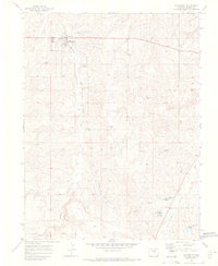
1970 Map of Elizabeth
USGS Topo · Published 1973About this map
Elizabeth serves as the focal point of this 1970s landscape, situated where Gold Run and Running Creek converge. The town's infrastructure at the time is clearly marked, including an Athletic Field, Rodeo Ground, and a local Water Tank. A distinctive piece of regional history is visible in the Old Railroad Grade that follows the Running Creek valley, marking the path of former rail commerce through Elbert County.
Find a feature on this map
32 named features on this map. Tap any name to fly to it.
Don’t see what you’re looking for? This feature index may not catch every label — zoom into the map to look around manually.
Map Details
Editions of this 1970 Elizabeth Map
4 editions found
Other maps of this area

1894 · Castle Rock
USGS Topo · 1:125,000

1913 · Castle Rock
USGS Topo · 1:125,000

1939 · Elizabeth
USGS Topo · 1:62,500

1940 · Elbert
USGS Topo · 1:62,500

1944 · Elbert
USGS Topo · 1:62,500

1945 · Elizabeth
USGS Topo · 1:62,500

1953 · Denver
USGS Topo · 1:250,000

1954 · Cherry Valley School
USGS Topo · 1:24,000

1957 · Denver
USGS Topo · 1:250,000

1958 · Denver
USGS Topo · 1:250,000