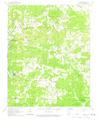
1966 Map of Elizabeth
USGS Topo · Published 1967About this map
Elizabeth and its surrounding hill country define this mid-1960s survey of the Fulton and Izard county line. The landscape is dominated by the winding course of Big Creek and its many tributaries, including South Brushy Creek and Hutchinson Creek. To the west, the map captures the rising waters of Norfork Lake, noting a normal pool elevation of 548 feet.
Find a feature on this map
29 named features on this map. Tap any name to fly to it.
Don’t see what you’re looking for? This feature index may not catch every label — zoom into the map to look around manually.
Map Details
Editions of this 1966 Elizabeth Map
This is the sole edition of this map. No revisions or reprints were ever made.
Other maps of this area

1890 · Mountain Home
USGS Topo · 1:125,000

1891 · Mountain Home
USGS Topo · 1:125,000

1894 · Mountain Home
USGS Topo · 1:125,000

1945 · Harrison
USGS Topo · 1:250,000

1949 · Harrison
USGS Topo · 1:250,000

1950 · Salem
USGS Topo · 1:62,500

1951 · Salem
USGS Topo · 1:62,500

1951 · Melbourne
USGS Topo · 1:62,500

1954 · Harrison
USGS Topo · 1:250,000

1957 · Poplar Bluff
USGS Topo · 1:250,000