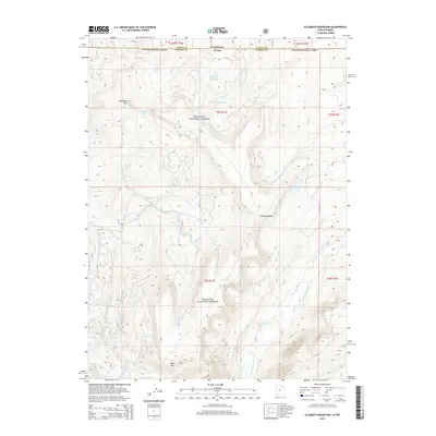
2014 Map of Elizabeth Mountain
USGS Topo · Published 2014About this map
Wasatch National Forest dominates this high-altitude landscape along the border of Utah and Wyoming. The terrain is defined by dramatic elevation changes, centered on the towering Elizabeth Mtn and the strategic Elizabeth Pass. Water sources are abundant throughout the quadrangle, with drainage systems such as W Fork Blacks Fork and McKenzie Cr cutting through the slopes. High-mountain bodies of water, including Elizabeth Lake, Lym Lake, and Fish Lake, suggest a pristine wilderness environment. In the northern reaches, the Moslander Reservoir serves as a significant hydrologic feature near the state line. The map also identifies Table Top, a distinctive plateau that stands out against the intricate network of creeks like Van Tassel Cr and Plot Cr. This 2014 survey documents a region where natural topography remains the primary feature, largely untouched by major development.
Find a feature on this map
23 named features on this map. Tap any name to fly to it.
Don’t see what you’re looking for? This feature index may not catch every label — zoom into the map to look around manually.
Map Details
Editions of this 2014 Elizabeth Mountain Map
This is the sole edition of this map. No revisions or reprints were ever made.
Other maps of this area

1885 · Uinta
USGS Topo · 1:250,000

1901 · Hayden Peak
USGS Topo · 1:125,000

1903 · Hayden Peak
USGS Topo · 1:125,000

1954 · Salt Lake City
USGS Topo · 1:250,000

1954 · Ogden
USGS Topo · 1:250,000

1958 · Ogden
USGS Topo · 1:250,000

1958 · Salt Lake City
USGS Topo · 1:250,000

1960 · Ogden
USGS Topo · 1:250,000

1960 · Salt Lake City
USGS Topo · 1:250,000
1965 · Pine Knoll
USGS Topo · 1:24,000