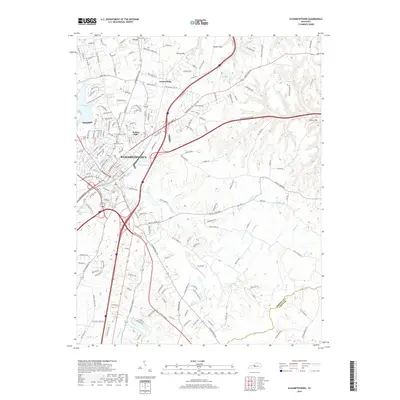
2019 Map of Elizabethtown
USGS Topo · Published 2019About this map
Elizabethtown serves as the focal point of this modern topographic survey, illustrating a landscape where established neighborhoods and historic burial grounds meet major transit corridors. Residential pockets like Indian Hills, Tunnel Hill, and Tunnel Hills are situated north of the city center, while the recreational waters of Freeman Lake and Buffalo Lake provide significant geographic landmarks within the municipal bounds. The town's historical roots are visible in several documented family and church sites, including Saint James Cem, McCullum Cem, and Browns Cem. To the east, the terrain transitions into Poplar Flats and the elevations of Miller Hill, drained by the winding courses of Valley Cr and Middle Cr. The presence of Oz Airport and the complex interchanges of the Bluegrass Parkway and Lincoln Pkwy underscore the area's role as a regional transportation hub in Hardin County.
Find a feature on this map
32 named features on this map. Tap any name to fly to it.
Don’t see what you’re looking for? This feature index may not catch every label — zoom into the map to look around manually.
Map Details
Editions of this 2019 Elizabethtown Map
This is the sole edition of this map. No revisions or reprints were ever made.
Other maps of this area

1935 · Elizabethtown
USGS Topo · 1:48,000

1936 · Vine Grove
USGS Topo · 1:62,500

1938 · Elizabethtown
USGS Topo · 1:62,500

1943 · Vine Grove
USGS Topo · 1:62,500

1946 · Colesburg
USGS Topo · 1:24,000

1946 · Vine Grove
USGS Topo · 1:24,000

1946 · Vine Grove
USGS Topo · 1:62,500

1948 · Cecilia
USGS Topo · 1:24,000

1949 · Sonora
USGS Topo · 1:24,000

1949 · Tonieville
USGS Topo · 1:24,000