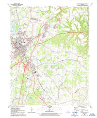
1991 Map of Elizabethtown
USGS Topo · Published 1991About this map
Elizabethtown sits at the intersection of several major transit corridors, reflecting its role as a regional hub in the late twentieth century. The landscape is defined by the convergence of the Blue Grass Parkway, Western Kentucky Parkway, and Lincoln Parkway, which wrap around the southern and eastern edges of the city. These modern routes contrast with the historical Old Railroad Grade and numerous small country churches like Severns Valley Ch and St James Ch that anchor the older residential and rural neighborhoods. To the north, Freeman Lake and its surrounding Freeman Lake Park provide a significant recreational anchor, while the surrounding terrain is marked by local high points such as Tunnel Hill and Miller Hill. The mapping of small features like Browns Cem and several Radio Towers indicates the complex layering of historical family land and modern infrastructure typical of this Kentucky county seat.
Find a feature on this map
47 named features on this map. Tap any name to fly to it.
Don’t see what you’re looking for? This feature index may not catch every label — zoom into the map to look around manually.
Map Details
Editions of this 1991 Elizabethtown Map
This is the sole edition of this map. No revisions or reprints were ever made.
Other maps of this area

1935 · Elizabethtown
USGS Topo · 1:48,000

1936 · Vine Grove
USGS Topo · 1:62,500

1938 · Elizabethtown
USGS Topo · 1:62,500

1943 · Vine Grove
USGS Topo · 1:62,500

1946 · Colesburg
USGS Topo · 1:24,000

1946 · Vine Grove
USGS Topo · 1:24,000

1946 · Vine Grove
USGS Topo · 1:62,500

1948 · Cecilia
USGS Topo · 1:24,000

1949 · Sonora
USGS Topo · 1:24,000

1949 · Tonieville
USGS Topo · 1:24,000