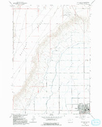
1966 Map of Elk Basin SE
USGS Topo · Published 1992About this map
Agricultural development and industrial transit define the landscape of northern Park County on this mid-century survey. The town of Powell serves as a hub for the surrounding Powell Flats, where a disciplined grid of irrigation infrastructure is evident through the presence of the Frannie Canal and several lateral roads such as Lateral Eleven Road. The terrain is dominated by the dramatic elevation of Polecat Bench to the west, a flat-topped landform that overlooks the valley floor. Evidence of the region's energy and resource sector is visible in a long-distance Pipeline cutting across the bench and a Gravel Pit near the Powell Municipal Airport. Local drainage is managed by Bitter Creek, which winds through the lower flats near the town site, illustrating the reliance on both natural and engineered water systems in this Wyoming basin.
Find a feature on this map
21 named features on this map. Tap any name to fly to it.
Don’t see what you’re looking for? This feature index may not catch every label — zoom into the map to look around manually.
Map Details
Editions of this 1966 Elk Basin SE Map
2 editions found
Other maps of this area

1955 · Cody
USGS Topo · 1:250,000

1958 · Cody
USGS Topo · 1:250,000

1962 · Cody
USGS Topo · 1:250,000

1966 · Elk Basin SW
USGS Topo · 1:24,000

1966 · Garland
USGS Topo · 1:24,000

1966 · Elk Basin
USGS Topo · 1:24,000

1966 · Elk Basin NW
USGS Topo · 1:24,000

1966 · Deaver Reservoir
USGS Topo · 1:24,000

1966 · Elk Basin SE
USGS Topo · 1:24,000

1966 · Gilmore Hill NW
USGS Topo · 1:24,000