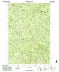
1994 Map of Elk Butte
USGS Topo · Published 1997About this map
Floodwood State Forest and the surrounding timberlands of Clearwater County define this 1990s landscape, which remains marked by the traces of earlier industrial logging operations. Several historical camp sites, including Johnson Camp, Bark Camp, and the Diamond Match Camp, point to the region's legacy of resource extraction. The topography is anchored by the prominent Elk Butte, home to the Elk Butte Lookout and the protected Elk Butte Mountain Hemlock Area. Waterways like Isabella Creek and Floodwood Creek cut through the terrain, which is also bisected by the 8th Standard Parallel North. This survey provides a clear look at the network of forest roads and ridges, such as Sourdough Ridge, that facilitated access to these remote northern Idaho woods.
Find a feature on this map
30 named features on this map. Tap any name to fly to it.
Don’t see what you’re looking for? This feature index may not catch every label — zoom into the map to look around manually.
Map Details
Editions of this 1994 Elk Butte Map
This is the sole edition of this map. No revisions or reprints were ever made.
Other maps of this area

1923 · Washington Creek
USGS Topo · 1:125,000

1936 · Boehls Butte
USGS Topo · 1:48,000

1938 · Headquarters
USGS Topo · 1:48,000

1943 · Boehls Butte
USGS Topo · 1:62,500

1944 · Headquarters
USGS Topo · 1:62,500

1955 · Pullman
USGS Topo · 1:250,000

1956 · Hamilton
USGS Topo · 1:250,000

1958 · Pullman
USGS Topo · 1:250,000

1959 · Hamilton
USGS Topo · 1:250,000

1960 · Hamilton
USGS Topo · 1:250,000