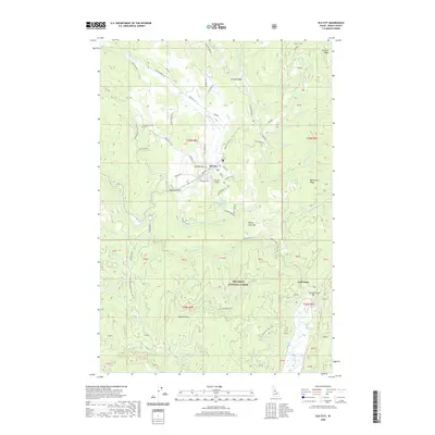
2020 Map of Elk City
USGS Topo · Published 2020About this map
Elk City sits as a central hub within the vast terrain of the Nez Perce National Forest, where a network of local roads and mountain trails converges. The settlement is defined by its placement near the confluence of the American River and the Red River, both of which feed into the S Fork Clearwater River. The landscape is dominated by high-elevation features like Mother Lode Hill, Wheeler Mtn, and Ericson Ridge, while smaller mining and settlement sites such as Buffalo Gulch and Gold Point are scattered throughout the drainages. Evidence of historic and ongoing land use is visible in the numerous Forest Service roads and landmarks like the Elk City Airport. The area's complex hydrology is meticulously detailed, tracing the paths of Big Elk Cr, Deadwood Cr, and Red Horse Cr through the deeply carved valleys of Idaho County.
Find a feature on this map
85 named features on this map. Tap any name to fly to it.
Don’t see what you’re looking for? This feature index may not catch every label — zoom into the map to look around manually.
Map Details
Editions of this 2020 Elk City Map
This is the sole edition of this map. No revisions or reprints were ever made.
Other maps of this area

1931 · Buffalo Hump
USGS Topo · 1:125,000

1934 · Buffalo Hump
USGS Topo · 1:125,000

1956 · Elk City
USGS Topo · 1:250,000

1960 · Elk City
USGS Topo · 1:250,000

1962 · Center Star Mtn
USGS Topo · 1:24,000

1962 · Iron Mtn
USGS Topo · 1:24,000

1966 · Elk City
USGS Topo · 1:24,000

1966 · Black Hawk Mtn
USGS Topo · 1:24,000

1966 · Lick Point
USGS Topo · 1:24,000

1966 · Anderson Butte
USGS Topo · 1:24,000