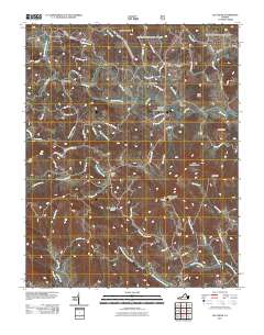
2011 Map of Elk Creek
USGS Topo · Published 2011About this map
Elk Creek serves as the focal point for this rural landscape in Grayson County, where the eponymous waterway and its many tributaries, such as Stone Creek, define the settlement patterns. The presence of Bennington Mill and the Reverend J W Rader Memorial Bridge speaks to a long-standing local infrastructure built around the creek system. Smaller communities like Comers Rock and Lower Elk Creek are connected by a network of winding roads like Comers Rock Rd and Saddle Creek Rd, which navigate the significant elevation changes of the Blue Ridge. High points such as Point Lookout Mountain and The Pinnacle provide dramatic natural landmarks overlooking the valley. The map details numerous smaller drainages, including Peach Bottom Creek and Powdermill Creek, illustrating a well-watered region where topography dictates the location of homes and agricultural land in gaps like Longs Gap and Hollow Rock Hollow.
Find a feature on this map
69 named features on this map. Tap any name to fly to it.
Don’t see what you’re looking for? This feature index may not catch every label — zoom into the map to look around manually.
Map Details
Editions of this 2011 Elk Creek Map
This is the sole edition of this map. No revisions or reprints were ever made.
Other maps of this area

1889 · Wytheville
USGS Topo · 1:125,000

1892 · Wytheville
USGS Topo · 1:125,000

1930 · Speedwell
USGS Topo · 1:62,500

1930 · Independence
USGS Topo · 1:48,000

1931 · Rural Retreat
USGS Topo · 1:48,000

1933 · Independence
USGS Topo · 1:62,500

1935 · Mouth of Wilson
USGS Topo · 1:48,000

1935 · Cedar Springs
USGS Topo · 1:24,000

1935 · Middle Fox Creek
USGS Topo · 1:24,000
1939 · Speedwell
USGS Topo · 1:62,500