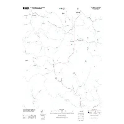
2013 Map of Elk Creek
USGS Topo · Published 2013About this map
Independence anchors the southern edge of this Blue Ridge landscape, where the headwaters of numerous creeks carve through a network of prominent peaks and gaps. The central corridor is defined by the Elk Creek Pkwy, which follows the path of Elk Creek past the settlements of Elk Creek and Lower Elk Creek. This modern survey documents the contemporary rural infrastructure of Grayson County, including agricultural landmarks like Rolling Acres Dairy and the Reverend J W Rader Memorial Bridge.
Find a feature on this map
82 named features on this map. Tap any name to fly to it.
Don’t see what you’re looking for? This feature index may not catch every label — zoom into the map to look around manually.
Map Details
Editions of this 2013 Elk Creek Map
This is the sole edition of this map. No revisions or reprints were ever made.
Other maps of this area

1889 · Wytheville
USGS Topo · 1:125,000

1892 · Wytheville
USGS Topo · 1:125,000

1930 · Speedwell
USGS Topo · 1:62,500

1930 · Independence
USGS Topo · 1:48,000

1931 · Rural Retreat
USGS Topo · 1:48,000

1933 · Independence
USGS Topo · 1:62,500

1935 · Mouth of Wilson
USGS Topo · 1:48,000

1935 · Cedar Springs
USGS Topo · 1:24,000

1935 · Middle Fox Creek
USGS Topo · 1:24,000
1939 · Speedwell
USGS Topo · 1:62,500