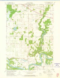
1972 Map of Elk Creek Lake
USGS Topo · Published 1975About this map
Elk Mound sits atop the northern heights of this landscape, overlooking a complex network of waterways that define the borderlands between Dunn and Eau Claire counties. In the early 1970s, the meandering Chippewa River dominates the southern reaches, flanked by the Chippewa Bottoms and the small settlement of Caryville. The map illustrates a rural economy reliant on rail and river, with the Chicago and North Western railroad cutting through the north while the Chicago Milwaukee St Paul and Pacific follows the river valley. For those tracing family histories, numerous burial grounds like St Joseph Cem, Evergreen Cem, and Spring Brook Cem are documented alongside local landmarks such as Amy Chapel and the Elk Creek State Public Fishing Area. The presence of several Gravel Pit locations and the sewage disposal site near the main town reflect the local infrastructure of the era.
Find a feature on this map
46 named features on this map. Tap any name to fly to it.
Don’t see what you’re looking for? This feature index may not catch every label — zoom into the map to look around manually.
Map Details
Editions of this 1972 Elk Creek Lake Map
This is the sole edition of this map. No revisions or reprints were ever made.
Other maps of this area

1929 · Durand
USGS Topo · 1:62,500

1932 · Durand
USGS Topo · 1:62,500

1932 · Mondovi
USGS Topo · 1:62,500

1934 · Elk Mound
USGS Topo · 1:62,500

1936 · Elk Mound
USGS Topo · 1:62,500

1940 · Menomonie
USGS Topo · 1:62,500

1942 · Menomonie
USGS Topo · 1:62,500

1953 · Eau Claire
USGS Topo · 1:250,000

1958 · Eau Claire
USGS Topo · 1:250,000

1964 · Eau Claire
USGS Topo · 1:250,000