1972 Map of Elk Meadow
USGS Topo · Published 1976About this map
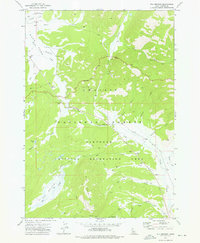
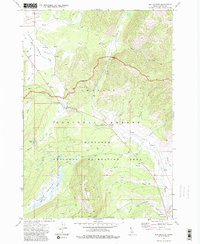
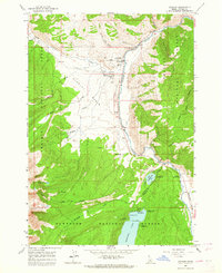
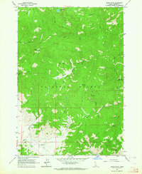
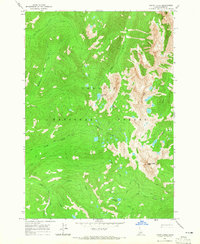
Elk Mountain and the surrounding high country of Custer County are documented here in the early 1970s, showcasing a landscape managed for both utility and recreation. The overlap of the Challis National Forest and the Sawtooth National Recreation Area is evident, with seasonal activity centers such as the Cap Horn Forest Service Station and various campgrounds providing anchor points for travelers. The map reveals a specific industrial footprint with several prospects and tailings near Valley Creek, alongside a high-altitude landing strip and a network of pack trails and jeep trails that navigate difficult terrain. Landmarks like Trap Creek Narrows and Blind Summit serve as critical navigation points through the valley corridors and mountain passes.
Find a feature on this map
36 named features on this map. Tap any name to fly to it.
Don’t see what you’re looking for? This feature index may not catch every label — zoom into the map to look around manually.
Map Details
Editions of this 1972 Elk Meadow Map
2 editions found
Other maps of this area

1891 · Bear Valley
USGS Topo · 1:125,000

1893 · Bear Valley
USGS Topo · 1:125,000

1919 · Custer
USGS Topo · 1:125,000

1922 · Custer
USGS Topo · 1:125,000

1957 · Challis
USGS Topo · 1:250,000

1960 · Challis
USGS Topo · 1:250,000

1963 · Challis
USGS Topo · 1:250,000
1963 · Stanley
USGS Topo · 1:24,000
1963 · Basin Butte
USGS Topo · 1:24,000
1964 · Knapp Lakes
USGS Topo · 1:24,000