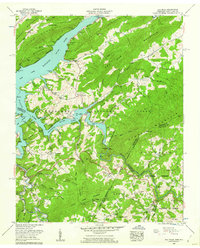
1959 Map of Elk Mills
USGS Topo · Published 1962About this map
The Watauga River and Elk River converge within this 1959 survey of the high country along the Tennessee and North Carolina border. This era marks the landscape after the creation of Watauga Lake, with the Watauga Reservation Boundary framing the inundated valleys of Roan Creek and Dry Run. While the rising waters altered the topography, many upland communities remain visible, including the small settlements of Elk Mills and Buntontown.
Find a feature on this map
103 named features on this map. Tap any name to fly to it.
Don’t see what you’re looking for? This feature index may not catch every label — zoom into the map to look around manually.
Map Details
Editions of this 1959 Elk Mills Map
4 editions found
Other maps of this area

1891 · Roan Mountain
USGS Topo · 1:125,000

1893 · Cranberry
USGS Topo · 1:125,000

1894 · Roan Mountain
USGS Topo · 1:125,000

1895 · Cranberry
USGS Topo · 1:125,000

1899 · Cranberry
USGS Topo · 1:125,000

1902 · Cranberry
USGS Topo · 1:125,000

1904 · Roan Mountain
USGS Topo · 1:125,000

1934 · Valle Crucis
USGS Topo · 1:24,000

1934 · White Rocks Mtn
USGS Topo · 1:24,000

1934 · Elk Park
USGS Topo · 1:24,000