1934 Map of Elk Mound
USGS Topo · Published 1966About this map
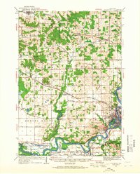
Chippewa River curves through this mid-1930s landscape, which documents the industrial and transit hubs of west-central Wisconsin. The city of Eau Claire anchors the southeastern corner, showing a dense grid near Mt Washington and Carson Park before the river winds past the lumber legacy at Porters Mills. In the north, Colfax and Albertville serve as primary rail stops along the Minneapolis St Paul and Sault Ste Marie line.
Find a feature on this map
74 named features on this map. Tap any name to fly to it.
Don’t see what you’re looking for? This feature index may not catch every label — zoom into the map to look around manually.
Map Details
Editions of this 1934 Elk Mound Map
2 editions found
Other maps of this area

1927 · Strum
USGS Topo · 1:62,500

1929 · Durand
USGS Topo · 1:62,500

1930 · Strum
USGS Topo · 1:62,500

1932 · Durand
USGS Topo · 1:62,500

1932 · Mondovi
USGS Topo · 1:62,500

1934 · Elk Mound
USGS Topo · 1:62,500

1934 · Chippewa Falls
USGS Topo · 1:62,500

1936 · Chippewa Falls
USGS Topo · 1:62,500

1936 · Elk Mound
USGS Topo · 1:62,500

1940 · Menomonie
USGS Topo · 1:62,500