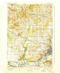
1936 Map of Elk Mound
USGS Topo · Published 1936About this map
Chippewa River meanders across the southern landscape of this mid-1930s survey, anchoring a network of small settlements and rural schoolhouses. The Chicago St Paul Minneapolis and Omaha Railway cuts westward through Elk Mound, while the Old Meridean Ferry provides a critical crossing point south of Caryville. This era reveals a highly localized education system, with dozens of named schools such as Oak Knoll Sch, Sunny Valley Sch, and Waneka Sch serving the farming townships of Wheaton, Howard, and Spring Brook. Notable landmarks like the Polo Grounds near Elk Creek Lake and The Yankee Woods north of the village of Elk Mound provide unique character to the agricultural terrain. The map also documents the growing footprint of Eau Claire in the southeast, including neighborhoods like Shawtown and Mt Washington.
Find a feature on this map
75 named features on this map. Tap any name to fly to it.
Don’t see what you’re looking for? This feature index may not catch every label — zoom into the map to look around manually.
Map Details
Editions of this 1936 Elk Mound Map
2 editions found
Other maps of this area

1927 · Strum
USGS Topo · 1:62,500

1929 · Durand
USGS Topo · 1:62,500

1930 · Strum
USGS Topo · 1:62,500

1932 · Durand
USGS Topo · 1:62,500

1932 · Mondovi
USGS Topo · 1:62,500

1934 · Elk Mound
USGS Topo · 1:62,500

1934 · Chippewa Falls
USGS Topo · 1:62,500

1936 · Chippewa Falls
USGS Topo · 1:62,500

1936 · Elk Mound
USGS Topo · 1:62,500

1940 · Menomonie
USGS Topo · 1:62,500