
1936 Map of Elk Mound
USGS Topo · Published 1936About this map
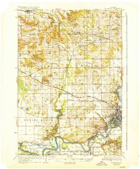
Chippewa River meanders through the southern half of this landscape, defining the rural economy of Dunn and Eau Claire Counties in the mid-1930s. The region is characterized by a dense network of one-room schoolhouses such as Waneka Sch, Sinking Creek Sch, and Bear Valley Sch, indicating a well-distributed agrarian population. Transport relies on a mix of early state highways and multiple rail lines, including the Chicago Milwaukee St Paul and Pacific, which serves the riverfront settlements. A notable transition is visible at Old Albertville, suggesting a shift in settlement patterns towards the newer Albertville. Local recreation and community hubs are prominently marked, from the Polo Grounds near Union to Carson Park on the edge of Eau Claire, while the Old Meridean Ferry still provides a vital river crossing point.
Find a feature on this map
71 named features on this map. Tap any name to fly to it.
Don’t see what you’re looking for? This feature index may not catch every label — zoom into the map to look around manually.
Map Details
Editions of this 1936 Elk Mound Map
2 editions found
Other maps of this area

1927 · Strum
USGS Topo · 1:62,500

1929 · Durand
USGS Topo · 1:62,500

1930 · Strum
USGS Topo · 1:62,500

1932 · Durand
USGS Topo · 1:62,500

1932 · Mondovi
USGS Topo · 1:62,500

1934 · Elk Mound
USGS Topo · 1:62,500

1934 · Chippewa Falls
USGS Topo · 1:62,500

1936 · Chippewa Falls
USGS Topo · 1:62,500

1940 · Menomonie
USGS Topo · 1:62,500

1942 · Menomonie
USGS Topo · 1:62,500