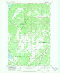
1968 Map of Elk
USGS Topo · Published 1971About this map
The Little Spokane River winds through the southeastern corner of this landscape, passing the community of Elk as it follows the Great Northern railroad line. This late-1960s survey documents a region defined by its narrow valleys and timbered highlands, where Fertile Valley, Shadow Valley, and Rogers Pass dictate the flow of travel and settlement. To the west, the waters of Eloika Lake reach into the quadrangle at Pocahontas Bay and Grays Landing, providing a clear record of the shoreline before later development.
Find a feature on this map
42 named features on this map. Tap any name to fly to it.
Don’t see what you’re looking for? This feature index may not catch every label — zoom into the map to look around manually.
Map Details
Editions of this 1968 Elk Map
Other maps of this area

1901 · Spokane
USGS Topo · 1:125,000

1936 · Newport
USGS Topo · 1:96,000

1942 · Newport
USGS Topo · 1:125,000

1943 · Mt Spokane
USGS Topo · 1:62,500

1949 · Deer Park
USGS Topo · 1:62,500

1950 · Mt Spokane
USGS Topo · 1:62,500

1951 · Deer Park
USGS Topo · 1:62,500

1955 · Spokane
USGS Topo · 1:250,000

1958 · Spokane
USGS Topo · 1:250,000

1958 · Sandpoint
USGS Topo · 1:250,000