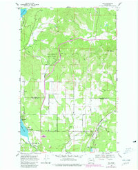
1968 Map of Elk
USGS Topo · Published 1981About this map
Fertile Valley and the surrounding timberland of Pend Oreille State Park dominate this late-twentieth-century landscape near the boundary of Pend Oreille and Spokane counties. The settlement of Elk serves as a local hub, situated along the Burlington Northern railroad line and the Little Spokane River. The map reveals a transition from the agricultural clearings in the south to the more complex topography of the north, where Bare Mountain and Rogers Pass rise above the drainage of Moon Creek and Otter Creek. Along the western edge, the shoreline of Eloika Lake features recreational and residential points such as Pocahontas Bay and Grays Landing, while the presence of Elk Cemetery and Camp Joubert provides specific points of interest for those researching local family history or community development in the Inland Northwest.
Find a feature on this map
38 named features on this map. Tap any name to fly to it.
Don’t see what you’re looking for? This feature index may not catch every label — zoom into the map to look around manually.
Map Details
Editions of this 1968 Elk Map
Other maps of this area

1901 · Spokane
USGS Topo · 1:125,000

1936 · Newport
USGS Topo · 1:96,000

1942 · Newport
USGS Topo · 1:125,000

1943 · Mt Spokane
USGS Topo · 1:62,500

1949 · Deer Park
USGS Topo · 1:62,500

1950 · Mt Spokane
USGS Topo · 1:62,500

1951 · Deer Park
USGS Topo · 1:62,500

1955 · Spokane
USGS Topo · 1:250,000

1958 · Spokane
USGS Topo · 1:250,000

1958 · Sandpoint
USGS Topo · 1:250,000