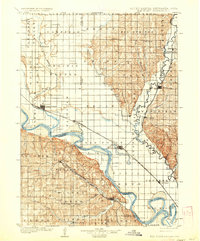
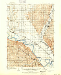
1907 Map of Elk Point
USGS Topo · Published 1936About this map
The Missouri River and Big Sioux River converge at the heart of this early twentieth-century tri-state borderlands survey, defining the fertile lowlands of South Dakota, Nebraska, and Iowa. This riverine landscape is governed by shifting channels and floodplains, evidenced by the oxbows of Mc Cook Lake and Lake Goodenough. Settlement patterns follow both the water and the iron, with the Chicago Milwaukee and St. Paul Ry. and the Sioux City and Dakota Ry. connecting essential trade hubs like Elk Point and Vermillion. Outside the rail corridors, the map documents a network of rural communities such as Dalesburg, Alsen, and Silver Ridge. Transportation across the major waterways still relied on river crossings like Vermilion Ferry and Ponca Ferry, highlighting the era's dependence on local river navigation before the widespread construction of modern bridges.
Find a feature on this map
81 named features on this map. Tap any name to fly to it.
Don’t see what you’re looking for? This feature index may not catch every label — zoom into the map to look around manually.
Map Details
Editions of this 1907 Elk Point Map
6 editions found
Other maps of this area

1897 · Canton
USGS Topo · 1:125,000

1898 · Parker
USGS Topo · 1:125,000

1898 · Elk Point
USGS Topo · 1:125,000

1900 · Canton
USGS Topo · 1:125,000

1901 · Elk Point
USGS Topo · 1:125,000

1907 · Elk Point
USGS Topo · 1:125,000

1955 · Sioux City
USGS Topo · 1:250,000

1955 · Sioux Falls
USGS Topo · 1:250,000

1958 · Sioux City
USGS Topo · 1:250,000

1958 · Sioux Falls
USGS Topo · 1:250,000