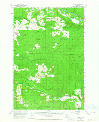
1953 Map of Elk Rock
USGS Topo · Published 1964About this map
The Cowlitz River and the North Fork Toutle River define the industrial and natural drainage of this southwest Washington landscape. Logistical footprints of the mid-century timber industry are prominent, with several logging camps including Camp Baker, Camp 9, and Camp 10 established deep within the timber stands. High-altitude watchfulness is noted at the Coyote Mtn Lookout and Elk Rock Lookout, while localized industry is evidenced by a Shingle Mill and Gravel Pit near the northern border. Small riverside settlements like Nesika and Alta Vista sit near the river bends, connected by a network of private and logging roads. The southern portion is dominated by the Green Mountain Range, while the Spirit Lake Highway provides a primary corridor through the valley before the landscape was fundamentally altered by volcanic activity in later decades.
Find a feature on this map
49 named features on this map. Tap any name to fly to it.
Don’t see what you’re looking for? This feature index may not catch every label — zoom into the map to look around manually.
Map Details
Editions of this 1953 Elk Rock Map

Other maps of this area

1916 · Chehalis
USGS Topo · 1:125,000

1919 · Mount St Helens
USGS Topo · 1:125,000

1937 · Eatonville
USGS Topo · 1:125,000

1942 · Toutle
USGS Topo · 1:62,500

1943 · Willapa
USGS Topo · 1:62,500

1943 · Pigeon Springs
USGS Topo · 1:62,500

1953 · Hoquiam
USGS Topo · 1:250,000

1953 · Toutle
USGS Topo · 1:62,500

1953 · Pigeon Springs
USGS Topo · 1:62,500

1953 · Cougar
USGS Topo · 1:62,500