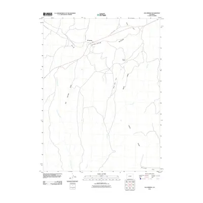
2010 Map of Elk Springs
USGS Topo · Published 2010About this map
Elk Springs serves as the focal point for this high-desert landscape in Moffat County, situated at a junction of regional roads including Bear Valley Rd and Deer Valley Rd. The topography is defined by the massive structural features of Elk Springs Ridge and Piñon Ridge, which dictate the drainage patterns for numerous seasonal waterways. The drainage network includes East Fork Wolf Creek to the west and Coal Creek to the east, carving deep incisions such as Elk Springs Draw and Winter Valley Gulch. These features reflect the erosion-shaped character of northwestern Colorado, where wide valleys like Winter Valley are separated by prominent limestone or sandstone ridges. The map captures the sparse settlement pattern and rural road infrastructure, including several county routes that link these remote ranching or energy-producing areas to the wider region.
Find a feature on this map
15 named features on this map. Tap any name to fly to it.
Don’t see what you’re looking for? This feature index may not catch every label — zoom into the map to look around manually.
Map Details
Editions of this 2010 Elk Springs Map
This is the sole edition of this map. No revisions or reprints were ever made.
Other maps of this area

1907 · Rangely
USGS Topo · 1:125,000

1907 · White River
USGS Topo · 1:125,000

1910 · White River
USGS Topo · 1:125,000

1910 · Rangely
USGS Topo · 1:125,000

1954 · Vernal
USGS Topo · 1:250,000

1958 · Vernal
USGS Topo · 1:250,000

1960 · Vernal
USGS Topo · 1:250,000

1960 · Elk Springs
USGS Topo · 1:62,500
1962 · Divide Creek
USGS Topo · 1:24,000
1962 · M F Mountain
USGS Topo · 1:24,000