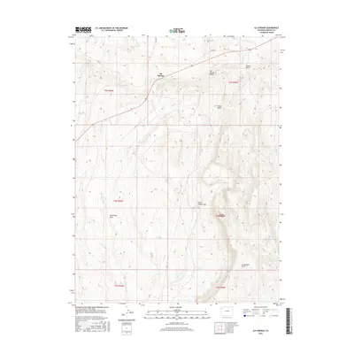
2016 Map of Elk Springs
USGS Topo · Published 2016About this map
Elk Springs sits at the northern edge of this high-desert landscape in Moffat County, where modern roadways meet the natural drainage patterns of the high plateau. The topography is defined by the prominent Elk Springs Ridge and Pinyon Ridge, which create a complex network of seasonal watercourses. Named features such as Winter Valley and Buffalo Gulch suggest a history of seasonal ranching and land use common to this part of the Colorado interior. The map clearly delineates the convergence of several canyons, including McAndrews Gulch and Winter Valley Gulch, illustrating the erosional forces that have shaped this terrain. The surveyor's placement of E Fork Wolf Cr and Coal Cr indicates the primary hydrographic outlets for the region's scattered draws and gulches.
Find a feature on this map
19 named features on this map. Tap any name to fly to it.
Don’t see what you’re looking for? This feature index may not catch every label — zoom into the map to look around manually.
Map Details
Editions of this 2016 Elk Springs Map
This is the sole edition of this map. No revisions or reprints were ever made.
Other maps of this area

1907 · Rangely
USGS Topo · 1:125,000

1907 · White River
USGS Topo · 1:125,000

1910 · White River
USGS Topo · 1:125,000

1910 · Rangely
USGS Topo · 1:125,000

1954 · Vernal
USGS Topo · 1:250,000

1958 · Vernal
USGS Topo · 1:250,000

1960 · Vernal
USGS Topo · 1:250,000

1960 · Elk Springs
USGS Topo · 1:62,500
1962 · Divide Creek
USGS Topo · 1:24,000
1962 · M F Mountain
USGS Topo · 1:24,000