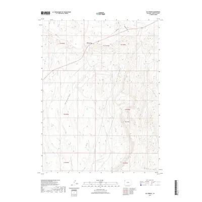
2019 Map of Elk Springs
USGS Topo · Published 2019About this map
Elk Springs sits at the northern edge of this high-desert landscape in Moffat County, where the terrain is defined by a series of prominent ridges and deep drainage systems. The settlement is positioned along the northern flank of Elk Springs Ridge, overlooking a network of seasonal watercourses including Elk Springs Draw and Buffalo Gulch. Further south, the topography rises significantly toward Pinyon Ridge, a major landform that separates the upper drainage basins from the winding course of Coal Cr and McAndrews Gulch near the southern boundary. The map provides a clear look at the rural road network, specifically Co Rd 14 and Co Rd 148, which serve as the primary access points through this remote section of Northwestern Colorado. This survey documents the intersection of public land survey sections and the natural erosional features of the high plateau country.
Find a feature on this map
17 named features on this map. Tap any name to fly to it.
Don’t see what you’re looking for? This feature index may not catch every label — zoom into the map to look around manually.
Map Details
Editions of this 2019 Elk Springs Map
This is the sole edition of this map. No revisions or reprints were ever made.
Other maps of this area

1907 · Rangely
USGS Topo · 1:125,000

1907 · White River
USGS Topo · 1:125,000

1910 · White River
USGS Topo · 1:125,000

1910 · Rangely
USGS Topo · 1:125,000

1954 · Vernal
USGS Topo · 1:250,000

1958 · Vernal
USGS Topo · 1:250,000

1960 · Vernal
USGS Topo · 1:250,000

1960 · Elk Springs
USGS Topo · 1:62,500
1962 · Divide Creek
USGS Topo · 1:24,000
1962 · M F Mountain
USGS Topo · 1:24,000