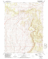
1986 Map of Elk Springs
USGS Topo · Published 1986About this map
Elk Springs stands as the primary point of human activity on this high desert landscape during the mid-1980s, situated along the northern reach of Elk Springs Ridge. The terrain is deeply carved by seasonal drainages and topographic features like Elk Springs Draw and Winter Valley Gulch, which feed into larger systems such as Coal Creek and Wolf Creek. This area of Moffat County shows a specific pattern of industrial exploration, with numerous labels for Oil Well and Gas Well sites alongside several exploratory Drill Hole markers. This infrastructure, often accessed by unimproved roads, highlights the intersection of the region's natural geography with late 20th-century energy development. The presence of named landmarks such as Pinon Ridge and Mc Andrews Gulch provides essential points of reference for those tracing historical land use or local genealogy in this corner of Colorado.
Find a feature on this map
16 named features on this map. Tap any name to fly to it.
Don’t see what you’re looking for? This feature index may not catch every label — zoom into the map to look around manually.
Map Details
Editions of this 1986 Elk Springs Map
This is the sole edition of this map. No revisions or reprints were ever made.
Other maps of this area

1907 · Rangely
USGS Topo · 1:125,000

1907 · White River
USGS Topo · 1:125,000

1910 · White River
USGS Topo · 1:125,000

1910 · Rangely
USGS Topo · 1:125,000

1954 · Vernal
USGS Topo · 1:250,000

1958 · Vernal
USGS Topo · 1:250,000

1960 · Vernal
USGS Topo · 1:250,000

1960 · Elk Springs
USGS Topo · 1:62,500
1962 · Divide Creek
USGS Topo · 1:24,000
1962 · M F Mountain
USGS Topo · 1:24,000