
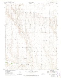
1972 Map of Elkader NW
USGS Topo · Published 1974About this map
Logan Monument dominates the western landscape of this Logan County terrain, where the high plains break into a network of draws and seasonal watercourses. The 1970s survey captures a sparse, working environment defined by the headwaters of South Branch Hackberry Creek and the meandering path of Plum Creek. Human presence is marked by isolated resource extraction sites, including a Sandpit and several Quarries, alongside scattered agricultural wells. A single, poignant Grave is noted on a high ridge overlooking the drainage basins, offering a specific point of interest for local historians and genealogists. The map illustrates a transitional zone between the townships of Oakley and Elkader, where the land-use patterns of the early 1970s emphasize the vast, open character of western Kansas prior to modern center-pivot irrigation expansion.
Find a feature on this map
9 named features on this map. Tap any name to fly to it.
Don’t see what you’re looking for? This feature index may not catch every label — zoom into the map to look around manually.
Map Details
Editions of this 1972 Elkader NW Map
This is the sole edition of this map. No revisions or reprints were ever made.
Other maps of this area

1954 · Goodland
USGS Topo · 1:250,000

1955 · Scott City
USGS Topo · 1:250,000

1956 · Goodland
USGS Topo · 1:250,000

1957 · Goodland
USGS Topo · 1:250,000

1958 · Scott City
USGS Topo · 1:250,000

1972 · Monument
USGS Topo · 1:24,000

1972 · Elkader NE
USGS Topo · 1:24,000
1972 · Russell Springs NE
USGS Topo · 1:24,000

1974 · Elkader SW
USGS Topo · 1:24,000

1974 · Elkader
USGS Topo · 1:24,000