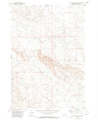
1980 Map of Elkhorn Creek SW
USGS Topo · Published 1980About this map
Owl Creek and its various tributaries define the drainage patterns of this southeastern Montana landscape in Carter County. The terrain is characterized by a dense network of intermittent watercourses and draws, reflecting a semi-arid environment where water management and seasonal flows were essential for local ranching operations. Significant drainages like Twelvemile Creek and Ninemile Creek suggest a nomenclature based on distance or travel intervals common in early frontier surveying. In the southern portion of the quadrangle, the South Fork Owl Creek and Crow Creek converge near sections of the Custer National Forest boundary. This 1980 map, based on aerial photography from the early 1970s, captures the land before significant modern development, showing a grid of section lines and unimproved roads that provided access to this remote rangeland.
Find a feature on this map
9 named features on this map. Tap any name to fly to it.
Don’t see what you’re looking for? This feature index may not catch every label — zoom into the map to look around manually.
Map Details
Editions of this 1980 Elkhorn Creek SW Map
This is the sole edition of this map. No revisions or reprints were ever made.
Other maps of this area

1901 · Aladdin
USGS Topo · 1:125,000

1903 · Aladdin
USGS Topo · 1:125,000

1954 · Ekalaka
USGS Topo · 1:250,000

1954 · Gillette
USGS Topo · 1:250,000

1955 · Gillette
USGS Topo · 1:250,000

1956 · Ekalaka
USGS Topo · 1:250,000

1957 · Mona
USGS Topo · 1:62,500

1957 · Colony
USGS Topo · 1:62,500

1958 · Gillette
USGS Topo · 1:250,000

1958 · Ekalaka
USGS Topo · 1:250,000