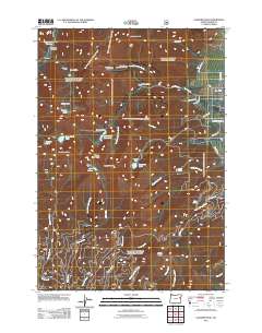
2011 Map of Elkhorn Peak
USGS Topo · Published 2011About this map
Elkhorn Peak dominates this high-altitude landscape in the Blue Mountains, where the legacies of early 20th-century lode mining remain visible. This 2011 survey illustrates a complex network of historic mining operations including the Upper Baisley-Elkhorn Mine, Middle Camp Baisley-Elkhorn Mine, and Lower Baisley-Elkhorn Mine. These sites, along with the Highland Mine and Maxwell Mine, mark a region defined by its industrial mineral extraction rather than permanent settlement. Water management for these operations and local agriculture is evidenced by the Williams Ditch and Nelson Ditch, which redirect snowmelt from high basins like Cougar Basin. Above the timberline, landmarks such as Rock Creek Butte and Hunt Mountain overlook alpine waters like Rock Creek Lake and Bucket Lake.
Find a feature on this map
48 named features on this map. Tap any name to fly to it.
Don’t see what you’re looking for? This feature index may not catch every label — zoom into the map to look around manually.
Map Details
Editions of this 2011 Elkhorn Peak Map
This is the sole edition of this map. No revisions or reprints were ever made.
Other maps of this area

1901 · Baker City
USGS Topo · 1:125,000

1901 · Sumpter
USGS Topo · 1:125,000

1955 · Baker
USGS Topo · 1:250,000

1955 · Canyon City
USGS Topo · 1:250,000

1959 · Baker
USGS Topo · 1:250,000

1959 · Canyon City
USGS Topo · 1:250,000
1967 · Haines
USGS Topo · 1:24,000

1967 · Blue Canyon
USGS Topo · 1:24,000
1967 · Wingville
USGS Topo · 1:24,000
1972 · Elkhorn Peak
USGS Topo · 1:24,000