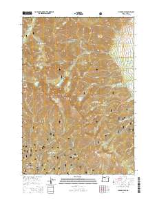
2014 Map of Elkhorn Peak
USGS Topo · Published 2014About this map
Elkhorn Peak and Rock Creek Butte anchor this high-elevation segment of the Elkhorn Mountains, where the landscape is defined by the steep divides of the Whitman National Forest. The map documents a complex water management system essential to the region's historical development, featuring several alpine reservoirs and man-made conduits such as Williams Ditch and Nelson Ditch. These features indicate the long-standing reliance on high-country snowmelt for lower-elevation agricultural or mining needs. Scattered throughout the basins are numerous small water bodies, including Willow Cr Lake, Goodrich Lake, and Twin Lakes. Large open areas like Eilertson Meadow contrast with the jagged Elkhorn Ridge, while the drainage network of Rock Cr, Pine Cr, and Marble Cr shows the natural flow patterns from these peaks toward the Baker Valley.
Find a feature on this map
52 named features on this map. Tap any name to fly to it.
Don’t see what you’re looking for? This feature index may not catch every label — zoom into the map to look around manually.
Map Details
Editions of this 2014 Elkhorn Peak Map
This is the sole edition of this map. No revisions or reprints were ever made.
Other maps of this area
1901 · Baker City
USGS Topo · 1:125,000
1901 · Sumpter
USGS Topo · 1:125,000

1955 · Baker
USGS Topo · 1:250,000

1955 · Canyon City
USGS Topo · 1:250,000

1959 · Baker
USGS Topo · 1:250,000

1959 · Canyon City
USGS Topo · 1:250,000
1967 · Haines
USGS Topo · 1:24,000
1967 · Blue Canyon
USGS Topo · 1:24,000
1967 · Wingville
USGS Topo · 1:24,000
1972 · Elkhorn Peak
USGS Topo · 1:24,000