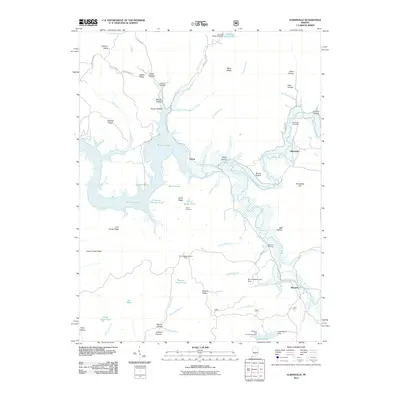
2011 Map of Elkinsville
USGS Topo · Published 2011About this map
Monroe Lake and its sprawling inlets dominate this portion of Brown County, where the valley of the Middle Fork Salt Creek meets complex ridges and hollows. The settlement of Elkinsville sits near the headwaters of the reservoir, adjacent to the Elkinsville Cemetery, while the small community of Maumee is positioned to the south near the Maumee Boy Scout Reservation. The landscape is defined by its dramatic relief, with named landforms like Browning Hill and Hickory Ridge rising above the water. Historical markers of the area's development are scattered throughout the hills, including the Hickory Ridge Lookout Tower and remote burial grounds such as Robinson Cemetery and Terrill Cemetery. This mapping shows the intricate network of ponds and minor branches, like Axsom Branch Pond and Hunter Creek Pond, which drain the heavily wooded Hoosier interior.
Find a feature on this map
71 named features on this map. Tap any name to fly to it.
Don’t see what you’re looking for? This feature index may not catch every label — zoom into the map to look around manually.
Map Details
Editions of this 2011 Elkinsville Map
This is the sole edition of this map. No revisions or reprints were ever made.
Other maps of this area

1934 · Bedford
USGS Topo · 1:48,000

1937 · Bedford
USGS Topo · 1:62,500

1942 · Franklin
USGS Topo · 1:125,000

1946 · Belmont
USGS Topo · 1:24,000

1947 · Allens Creek
USGS Topo · 1:24,000

1947 · Unionville
USGS Topo · 1:24,000

1947 · Nashville
USGS Topo · 1:24,000

1947 · Elkinsville
USGS Topo · 1:24,000

1949 · Nashville
USGS Topo · 1:24,000

1950 · Belmont
USGS Topo · 1:24,000