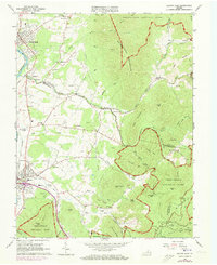
1965 Map of Elkton East
USGS Topo · Published 1973About this map
Elkton and the surrounding Shenandoah Valley foothills are captured here at a moment of significant topographic transition. The landscape is defined by the sharp rise of the Blue Ridge and Grindstone Mountain, where the Shenandoah National Park boundary meets established valley communities. Small settlements like Jollett, Furnace, and Comertown dot the lowlands, connected by a network of rural roads and the Norfolk and Western railroad.
Find a feature on this map
81 named features on this map. Tap any name to fly to it.
Don’t see what you’re looking for? This feature index may not catch every label — zoom into the map to look around manually.
Map Details
Editions of this 1965 Elkton East Map
Other maps of this area

1892 · Woodstock
USGS Topo · 1:125,000

1892 · Gordonsville
USGS Topo · 1:125,000

1892 · Harrisonburg
USGS Topo · 1:125,000

1893 · Luray
USGS Topo · 1:125,000

1905 · Luray
USGS Topo · 1:125,000

1929 · Stony Man
USGS Topo · 1:48,000

1930 · Madison
USGS Topo · 1:48,000

1933 · Stony Man
USGS Topo · 1:62,500

1933 · Madison
USGS Topo · 1:62,500

1937 · Elkton
USGS Topo · 1:62,500