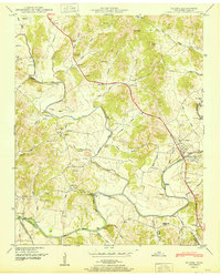
1951 Map of Elkton
USGS Topo · Published 1951About this map
Elk River winds through southern Giles County, shaping a landscape defined by sharp bends and productive bottomlands during the early 1950s. The town of Elkton serves as a local hub near the Elk River, while smaller communities like Aspen Hill and Prospect anchor the surrounding rural sections. The industrial history of the region is evident in the presence of Vinta Mill and Morrell Mill, situated alongside the numerous creeks feeding into the main river channel.
Find a feature on this map
80 named features on this map. Tap any name to fly to it.
Don’t see what you’re looking for? This feature index may not catch every label — zoom into the map to look around manually.
Map Details
Editions of this 1951 Elkton Map
2 editions found
Other maps of this area

1888 · Huntsville
USGS Topo · 1:125,000

1892 · Huntsville
USGS Topo · 1:125,000

1936 · Aspen Hill
USGS Topo · 1:24,000

1936 · Elkmont
USGS Topo · 1:24,000

1936 · Ardmore
USGS Topo · 1:24,000

1936 · Pulaski
USGS Topo · 1:24,000

1936 · Tarpley
USGS Topo · 1:24,000

1936 · Elkton
USGS Topo · 1:24,000

1936 · Frankewing
USGS Topo · 1:24,000

1936 · Dellrose
USGS Topo · 1:24,000