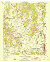
1951 Map of Elkton
USGS Topo · Published 1967About this map
The Elk River winds through the southern reaches of Giles County, serving as a primary corridor for settlement and early industry alongside the Louisville and Nashville railroad. This landscape is defined by its numerous small-scale water-powered operations, including Vesta Mill and Morrell Mill, which anchored local commerce before the mid-century expansion of modern infrastructure. The community at Elkton serves as a focal point near the river, while the Bee Line Highway cuts across the center, signaling the shift toward automotive transit in the region.
Find a feature on this map
86 named features on this map. Tap any name to fly to it.
Don’t see what you’re looking for? This feature index may not catch every label — zoom into the map to look around manually.
Map Details
Editions of this 1951 Elkton Map
2 editions found
Other maps of this area

1888 · Huntsville
USGS Topo · 1:125,000

1892 · Huntsville
USGS Topo · 1:125,000

1936 · Aspen Hill
USGS Topo · 1:24,000

1936 · Elkmont
USGS Topo · 1:24,000

1936 · Ardmore
USGS Topo · 1:24,000

1936 · Pulaski
USGS Topo · 1:24,000

1936 · Tarpley
USGS Topo · 1:24,000

1936 · Elkton
USGS Topo · 1:24,000

1936 · Frankewing
USGS Topo · 1:24,000

1936 · Dellrose
USGS Topo · 1:24,000