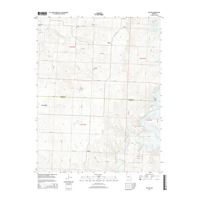
2015 Map of Elkton
USGS Topo · Published 2015About this map
Elkton and the surrounding rural landscape of the Missouri Ozarks are detailed in this 2015 study, which highlights a network of small agricultural settlements and natural water features. The map straddles the boundary of Hickory Co and Polk Co, centering on a plateau divided by several significant drainages. The eastern portion of the sheet is dominated by the upper reaches of Pomme de Terre Lake and the meandering Pomme de Terre River, while Weaubleau Cr flows through the western sections near Flemington. Local history is anchored by several family-named burial grounds, including Rountree Cemetery and Cook Cemetery to the north, and McCracken Cemetery near the center. These sites, along with the hamlet of Rondo, offer a clear picture of the region's enduring rural character and historical family ties to the land.
Find a feature on this map
60 named features on this map. Tap any name to fly to it.
Don’t see what you’re looking for? This feature index may not catch every label — zoom into the map to look around manually.
Map Details
Editions of this 2015 Elkton Map
This is the sole edition of this map. No revisions or reprints were ever made.
Other maps of this area

1884 · Bolivar
USGS Topo · 1:125,000

1886 · Stockton
USGS Topo · 1:125,000

1892 · Bolivar
USGS Topo · 1:125,000

1940 · Weaubleau
USGS Topo · 1:24,000

1942 · Elkton
USGS Topo · 1:24,000

1944 · Humansville
USGS Topo · 1:24,000
1944 · Weaubleau
USGS Topo · 1:24,000

1949 · Elkton
USGS Topo · 1:24,000

1949 · Sentinel
USGS Topo · 1:24,000

1950 · Elkton
USGS Topo · 1:24,000