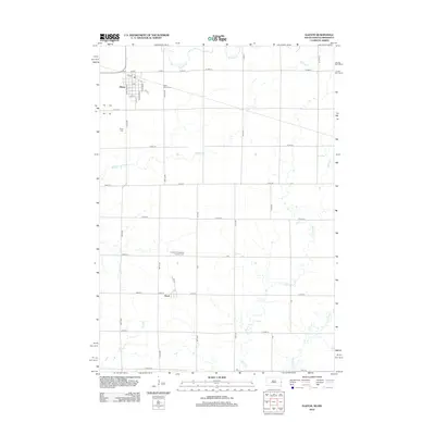
2012 Map of Elkton
USGS Topo · Published 2012About this map
Elkton anchors this 2012 survey, situated in the northwestern corner of the quadrangle where Co HWY-13 meets 1st ST. The town’s grid-based street plan, featuring names like Cornelius Ave and Antelope St, centers around its local Post Office, which serves as a landmark for the community. This prairie landscape is defined by its agricultural layout, punctuated by several historic burial grounds including Saint Marys Cem and Trinity Cem.
Find a feature on this map
52 named features on this map. Tap any name to fly to it.
Don’t see what you’re looking for? This feature index may not catch every label — zoom into the map to look around manually.
Map Details
Editions of this 2012 Elkton Map
This is the sole edition of this map. No revisions or reprints were ever made.
Other maps of this area

1953 · Watertown
USGS Topo · 1:250,000

1958 · Watertown
USGS Topo · 1:250,000

1967 · Pipestone North
USGS Topo · 1:24,000

1967 · Elkton SW
USGS Topo · 1:24,000

1967 · Verdi
USGS Topo · 1:24,000

1967 · Lake Benton
USGS Topo · 1:24,000

1967 · Lake Benton SW
USGS Topo · 1:24,000

1967 · Elkton
USGS Topo · 1:24,000

1972 · Flandreau NE
USGS Topo · 1:24,000
1972 · White SE
USGS Topo · 1:24,000