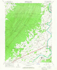
1965 Map of Elkton West
USGS Topo · Published 1966About this map
The South Fork Shenandoah River carves a path through the valley between the ridges of the George Washington National Forest and Shenandoah National Park in this mid-1960s survey. The landscape is defined by the steep, parallel ridges of Massanutten Mountain, including First Mountain through Fourth Mountain, which creates a natural barrier punctuated only by narrow gaps like Fridley Gap and Peterfish Gap. Human settlement is concentrated in the fertile lowlands, with the established communities of Elkton, Shenandoah, and McGaheysville linked by the Norfolk and Western Railway and Chesapeake Western Railway. Cultural sites are numerous across the valley floor, ranging from local landmarks like the Drive-in Theater near Solsburg to a network of rural houses of worship including Mt Zion Ch, Mt Sinai Ch, and Bethel Ch. This era shows a mix of traditional agriculture and mid-century infrastructure, such as the Filtration Plant and various landing strips alongside the winding course of Quail Run and Boone Run.
Find a feature on this map
59 named features on this map. Tap any name to fly to it.
Don’t see what you’re looking for? This feature index may not catch every label — zoom into the map to look around manually.
Map Details
Editions of this 1965 Elkton West Map
4 editions found
Other maps of this area

1892 · Woodstock
USGS Topo · 1:125,000

1892 · Harrisonburg
USGS Topo · 1:125,000

1937 · Elkton
USGS Topo · 1:62,500

1941 · Harrisonburg
USGS Topo · 1:62,500

1942 · Mt Jackson
USGS Topo · 1:62,500

1943 · Harrisonburg
USGS Topo · 1:62,500

1946 · Mt Jackson
USGS Topo · 1:62,500

1947 · Mt Jackson
USGS Topo · 1:62,500

1947 · Broadway
USGS Topo · 1:62,500

1949 · Charlottesville
USGS Topo · 1:250,000