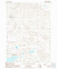
1985 Map of Ell Lake
USGS Topo · Published 1986About this map
Schlagel Creek winds through the northwestern corner of this Sandhills landscape, anchored by the Schlagel Creek State Wildlife Management Area. This mid-1980s survey captures a region defined by extensive wetland systems and large-scale ranching operations, including the Lovejoy Ranch, Churchill Ranch, and Baker Ranch. These family-named landmarks are situated among a high density of water bodies, from the prominent Ell Lake and Big Alkali Lake to the smaller Smith Lake and Rogers Lake.
Find a feature on this map
19 named features on this map. Tap any name to fly to it.
Don’t see what you’re looking for? This feature index may not catch every label — zoom into the map to look around manually.
Map Details
Editions of this 1985 Ell Lake Map
This is the sole edition of this map. No revisions or reprints were ever made.
Other maps of this area

1950 · Sparks
USGS Topo · 1:62,500

1950 · Simeon
USGS Topo · 1:62,500

1950 · Arabia
USGS Topo · 1:62,500

1950 · Valentine
USGS Topo · 1:62,500

1957 · Valentine
USGS Topo · 1:250,000

1959 · Valentine
USGS Topo · 1:250,000

1983 · Valentine SW
USGS Topo · 1:24,000

1983 · Valentine South
USGS Topo · 1:24,000
1983 · Thatcher
USGS Topo · 1:24,000
1985 · Arabia SW
USGS Topo · 1:24,000