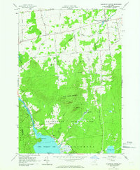
1964 Map of Ellenburg Center
USGS Topo · Published 1966About this map
Ellenburg Center serves as the primary hub of this northern Clinton County landscape in the mid-1960s, situated where the Chazy River meets a network of local roads like Patnode Road and Smith Road. The geography is defined by a transition from the lower agricultural and residential reaches near Harrigan to the heavily forested elevations of the Adirondack State Park. This protected boundary encompasses significant peaks such as Spruce Hill and Panther Hill, alongside numerous gravel pits that suggest the local industry of the era.
Find a feature on this map
48 named features on this map. Tap any name to fly to it.
Don’t see what you’re looking for? This feature index may not catch every label — zoom into the map to look around manually.
Map Details
Editions of this 1964 Ellenburg Center Map
This is the sole edition of this map. No revisions or reprints were ever made.
Other maps of this area

1906 · Loon Lake
USGS Topo · 1:62,500

1908 · Loon Lake
USGS Topo · 1:62,500

1911 · Lyon Mountain
USGS Topo · 1:62,500

1913 · Lyon Mountain
USGS Topo · 1:62,500

1915 · Churubusco
USGS Topo · 1:62,500

1915 · Chateaugay
USGS Topo · 1:62,500

1931 · Lyon Mountain
USGS Topo · 1:62,500

1943 · Churubusco
USGS Topo · 1:62,500

1943 · Chateaugay
USGS Topo · 1:62,500

1948 · Ogdensburg
USGS Topo · 1:250,000