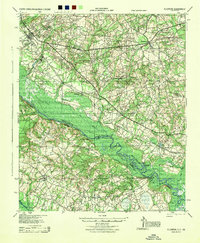
1944 Map of Ellenton
USGS Topo · Published 1944About this map
Ellenton and Dunbarton anchor this mid-1940s landscape, centers of a rural community that would soon undergo radical change. The map depicts a sophisticated transportation network where the Charleston and Western Carolina and Atlantic Coast Line railroads intersect, facilitating the movement of goods from industrial sites like Meyers Mill. Along the meandering Savannah River, numerous landings such as Little Hell Landing and Stony Bluff Landing signify a deep-rooted river economy.
Find a feature on this map
48 named features on this map. Tap any name to fly to it.
Don’t see what you’re looking for? This feature index may not catch every label — zoom into the map to look around manually.
Map Details
Editions of this 1944 Ellenton Map
This is the sole edition of this map. No revisions or reprints were ever made.
Other maps of this area

1919 · Allendale
USGS Topo · 1:62,500

1920 · Ellenton
USGS Topo · 1:48,000

1920 · Hilltonia
USGS Topo · 1:62,500

1920 · Millen
USGS Topo · 1:62,500

1920 · Greens Cut
USGS Topo · 1:62,500

1920 · Peeples
USGS Topo · 1:62,500

1920 · Talatha
USGS Topo · 1:48,000

1921 · Augusta
USGS Topo · 1:62,500

1921 · Talatha
USGS Topo · 1:62,500

1921 · Ellenton
USGS Topo · 1:62,500