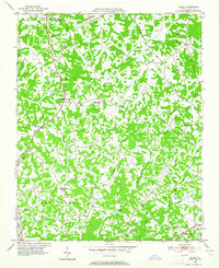
1949 Map of Eller
USGS Topo · Published 1964About this map
Eller and Gum Tree serve as the primary crossroads in this rural landscape of northern Davidson County during the late 1940s. The region is characterized by a dense network of country churches that acted as community anchors, including Hebron Ch, Bethlehem Ch, Canaan Ch, and Shady Grove Ch. Educational life is centered around local institutions like Midway Sch and Pilot Sch, reflecting a distributed settlement pattern common before post-war consolidation.
Find a feature on this map
35 named features on this map. Tap any name to fly to it.
Don’t see what you’re looking for? This feature index may not catch every label — zoom into the map to look around manually.
Map Details
Editions of this 1949 Eller Map
2 editions found
Other maps of this area

1949 · Eller
USGS Topo · 1:24,000

1949 · High Point West
USGS Topo · 1:24,000

1950 · Winston-Salem West
USGS Topo · 1:24,000

1950 · Lexington East
USGS Topo · 1:24,000

1950 · Winston-Salem East
USGS Topo · 1:24,000

1950 · Lexington West
USGS Topo · 1:24,000

1951 · Winston-Salem West
USGS Topo · 1:24,000

1951 · Winston-Salem East
USGS Topo · 1:24,000

1951 · Lexington East
USGS Topo · 1:24,000

1951 · Lexington West
USGS Topo · 1:24,000