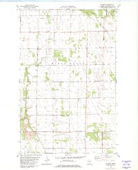
1982 Map of Ellerth
USGS Topo · Published 1982About this map
The agrarian landscape of Marshall County is defined here by the meeting of the Middle River and Snake River, where a complex network of man-made waterways like Main Judicial Ditch No 15 and County Ditch No 23 support the flat plains of Marsh Grove and West Valley. This 1982 survey captures the small community of Ellerth, anchored by the Bethania Ch and the nearby Bethesda Cem. The map provides a detailed view of the region's infrastructure, including a prominent pipeline and several Gravel Pits, illustrating the intersection of natural drainage and systematic land management in northwestern Minnesota. For genealogists and local historians, the inclusion of specific churches, cemeteries, and township boundaries like New Maine and Viking offers a clear look at the settlement patterns of the late twentieth century.
Find a feature on this map
16 named features on this map. Tap any name to fly to it.
Don’t see what you’re looking for? This feature index may not catch every label — zoom into the map to look around manually.
Map Details
Editions of this 1982 Ellerth Map
This is the sole edition of this map. No revisions or reprints were ever made.
Other maps of this area

1918 · Angus
USGS Topo · 1:62,500

1918 · Viking
USGS Topo · 1:62,500

1952 · Thief River Falls
USGS Topo · 1:250,000

1956 · Thief River Falls
USGS Topo · 1:250,000

1956 · Florian
USGS Topo · 1:62,500

1957 · Thief River Falls
USGS Topo · 1:250,000

1957 · Newfolden
USGS Topo · 1:62,500

1959 · Viking
USGS Topo · 1:24,000

1959 · Rosewood
USGS Topo · 1:24,000

1961 · Radium
USGS Topo · 1:24,000