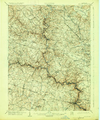
1906 Map of Ellicott
USGS Topo · Published 1926About this map
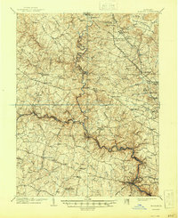
The Patapsco River carves a deep, winding course through this early 20th-century landscape, serving as the primary geographic anchor for the region's development. Along its banks and tributaries, a network of industrial and institutional landmarks emerges, including the Glee Mill and Carroll Mill, reflecting a rural economy tied to water power. Large-scale institutional holdings are prominent features of the terrain, notably the sprawling grounds of Springfield Hospital and educational centers such as St Charles College and the McDonogh School.
Find a feature on this map
80 named features on this map. Tap any name to fly to it.
Don’t see what you’re looking for? This feature index may not catch every label — zoom into the map to look around manually.
Map Details
Editions of this 1906 Ellicott Map
6 editions found

Other maps of this area

1892 · Laurel
USGS Topo · 1:62,500

1892 · Ellicott
USGS Topo · 1:62,500

1893 · Frederick
USGS Topo · 1:125,000

1894 · Ellicott
USGS Topo · 1:62,500

1894 · Laurel
USGS Topo · 1:62,500

1894 · Baltimore
USGS Topo · 1:62,500

1894 · Frederick
USGS Topo · 1:125,000

1894 · Relay
USGS Topo · 1:62,500

1897 · Laurel
USGS Topo · 1:62,500

1899 · Baltimore
USGS Topo · 1:62,500