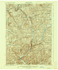
1924 Map of Ellicottville
USGS Topo · Published 1936About this map
Ellicottville serves as the focal point for this 1920s survey of Cattaraugus County, showing a landscape defined by the deep valleys and high ridges of the Allegany Plateau. The Buffalo, Rochester and Pittsburgh Railroad follows the winding path of Great Valley Creek, connecting remote hamlets like West Valley and Ashford to regional trade centers. The map reveals an exceptionally dense network of early 20th-century rural education, marking dozens of specific sites such as the Fancy Tract School, Rock Spring School, and Hadley School. Local industry and social life are anchored in small settlements such as Ashford Hollow and Thomas Corners, while the terrain itself bears the names of early settlers, from Mc Kinstry Hollow to Hencoop Hollow. This document provides a clear look at the region before modern highway development, preserving the locations of vanished rail stops like Riceville Sta and Edies Siding.
Find a feature on this map
108 named features on this map. Tap any name to fly to it.
Don’t see what you’re looking for? This feature index may not catch every label — zoom into the map to look around manually.
Map Details
Editions of this 1924 Ellicottville Map
3 editions found
Other maps of this area

1898 · Olean
USGS Topo · 1:62,500

1900 · Salamanca
USGS Topo · 1:62,500

1905 · Eden
USGS Topo · 1:62,500

1907 · Eden
USGS Topo · 1:62,500

1922 · Randolph
USGS Topo · 1:62,500

1923 · Randolph
USGS Topo · 1:62,500

1923 · Cattaraugus
USGS Topo · 1:62,500

1923 · Arcade
USGS Topo · 1:62,500

1924 · Ellicottville
USGS Topo · 1:62,500

1924 · Franklinville
USGS Topo · 1:62,500