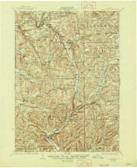
1924 Map of Ellicottville
USGS Topo · Published 1947About this map
Ellicottville and the surrounding Cattaraugus County uplands are captured here during the mid-1920s, a period defined by a dense network of rural school districts and small rail settlements. The Buffalo Rochester and Pittsburgh Railroad serves as a primary north-south artery, connecting depots at West Valley Sta and Riceville Sta while following the valley floors. The landscape is dotted with localized social centers such as the Dutch Hill Church and numerous numbered schools, including the Fancy Tract School and Wolf School, reflecting a highly decentralized community structure before the consolidation of the mid-20th century.
Find a feature on this map
101 named features on this map. Tap any name to fly to it.
Don’t see what you’re looking for? This feature index may not catch every label — zoom into the map to look around manually.
Map Details
Editions of this 1924 Ellicottville Map
3 editions found
Other maps of this area

1898 · Olean
USGS Topo · 1:62,500

1900 · Salamanca
USGS Topo · 1:62,500

1905 · Eden
USGS Topo · 1:62,500

1907 · Eden
USGS Topo · 1:62,500

1922 · Randolph
USGS Topo · 1:62,500

1923 · Randolph
USGS Topo · 1:62,500

1923 · Cattaraugus
USGS Topo · 1:62,500

1923 · Arcade
USGS Topo · 1:62,500

1924 · Ellicottville
USGS Topo · 1:62,500

1924 · Franklinville
USGS Topo · 1:62,500